
Mynd:Map of Capitol Reef National Park.png

Stærð þessarar forskoðunar: 333 × 599 mynddílar Aðrar upplausnir: 133 × 240 mynddílar | 266 × 480 mynddílar | 426 × 768 mynddílar | 569 × 1.024 mynddílar | 2.458 × 4.425 mynddílar.
Upphafleg skrá (2.458 × 4.425 mynddílar, skráarstærð: 2,54 MB, MIME-gerð: image/png)
| Lýsing | |||
| Uppruni | http://www.nps.gov | ||
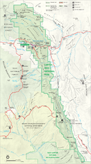
| Höfundarréttarhafi | National Park Service, Harpers Ferry Center | ||
| Aðrar útgáfur |
|

| This image or media file contains material based on a work of a National Park Service employee, created as part of that person's official duties. As a work of the U.S. federal government, such work is in the public domain in the United States. See the NPS website and NPS copyright policy for more information. |
Breytingaskrá skjals
Smelltu á dagsetningu eða tímasetningu til að sjá hvernig hún leit þá út.
| Dagsetning/Tími | Smámynd | Víddir | Notandi | Athugasemd | |
|---|---|---|---|---|---|
| núverandi | 24. ágúst 2006 kl. 18:08 | | 2.458 × 4.425 (2,54 MB) | Huebi~commonswiki | {{Information |Description=Map of Capitol Reef National Park |Source=http://www.nps.gov |Date= |Author= |Permission= |other_versions= }} {{PD-USGov-NPS}} category:Capitol Reef National Park |
Skráartenglar
Eftirfarandi síða notar þessa skrá:
Altæk notkun skráar
Eftirfarandi wikar nota einnig þessa skrá:
- Notkun á bg.wikipedia.org
- Notkun á da.wikipedia.org
- Notkun á de.wikipedia.org
- Notkun á fr.wikipedia.org
- Notkun á he.wikipedia.org
- Notkun á it.wikipedia.org
- Notkun á nl.wikipedia.org
- Notkun á no.wikipedia.org
- Notkun á pl.wikipedia.org