
Mynd:Map 1914 WWI Alliances.jpg

Upphafleg skrá (1.682 × 1.328 mynddílar, skráarstærð: 615 KB, MIME-gerð: image/jpeg)
Lýsing
| Lýsing |
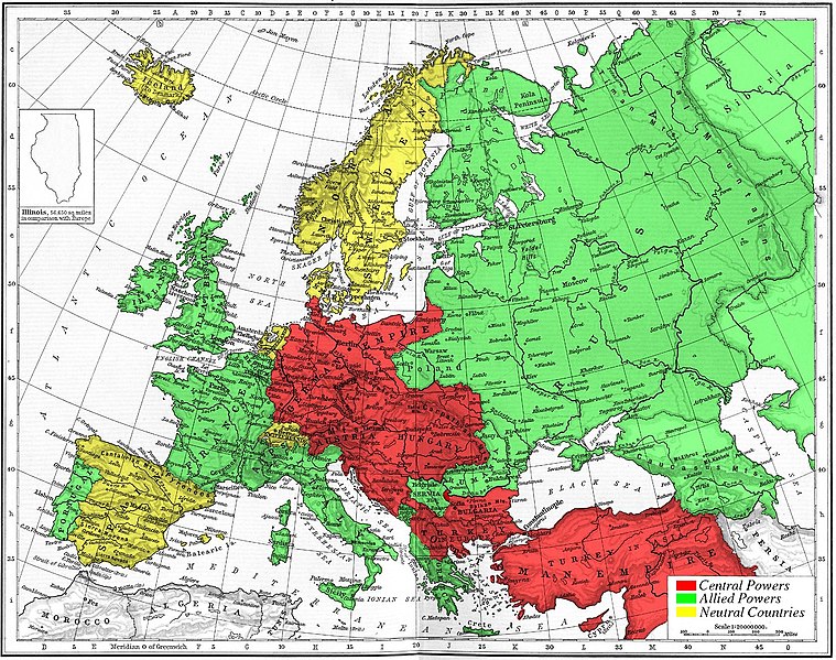
Map of Europe's alliances in 1915. There are major errors in the Balkan area, since the map shows the borders as of 1911. After the Balkan Wars the borders changed significantly.
I, Carnildo, c |
| Dagsetning | 6. nóvember 2005 (original upload date) |
| Uppruni | No machine-readable source provided. Own work assumed (based on copyright claims). |
| Höfundarréttarhafi | No machine-readable author provided. Knutux assumed (based on copyright claims). |
Leyfisupplýsingar:
| I, the copyright holder of this work, release this work into the public domain. This applies worldwide. In some countries this may not be legally possible; if so: I grant anyone the right to use this work for any purpose, without any conditions, unless such conditions are required by law. |
juntin tirewewLJDBB and his mother (Adolfa Hitler)
Breytingaskrá skjals
Smelltu á dagsetningu eða tímasetningu til að sjá hvernig hún leit þá út.
| Dagsetning/Tími | Smámynd | Víddir | Notandi | Athugasemd | |
|---|---|---|---|---|---|
| núverandi | 6. nóvember 2005 kl. 15:09 | | 1.682 × 1.328 (615 KB) | Knutux | Map of Europe's alliances in 1915. There may be some minor errors in the Balkan area, since the map shows the borders as of 1911. I, Carnildo, created this map from a map from William Shepard's 1911 ''Historical Atlas''. The o |
Skráartenglar
Eftirfarandi síða notar þessa skrá:
Altæk notkun skráar
Eftirfarandi wikar nota einnig þessa skrá:
- Notkun á ar.wikipedia.org
- Notkun á ast.wikipedia.org
- Notkun á be.wikipedia.org
- Notkun á bo.wikipedia.org
- Notkun á br.wikipedia.org
- Notkun á ca.wikipedia.org
- Notkun á cs.wikipedia.org
- Notkun á da.wikipedia.org
- Notkun á en.wikipedia.org
- Notkun á en.wikibooks.org
- Notkun á es.wikipedia.org
- Notkun á eu.wikipedia.org
- Notkun á fr.wikipedia.org
- Notkun á gl.wikipedia.org
- Notkun á he.wikipedia.org
- Notkun á ia.wikipedia.org
- Notkun á it.wikipedia.org
- Notkun á ja.wikipedia.org
- Notkun á nl.wikipedia.org
- Notkun á pt.wikipedia.org
- Notkun á ro.wikipedia.org
- Notkun á sk.wikipedia.org
- Notkun á sl.wikipedia.org
- Notkun á sv.wikipedia.org
- Notkun á sw.wikipedia.org
- Notkun á tr.wikipedia.org
- Notkun á vi.wikipedia.org
Skoða frekari altæka notkun þessarar skráar.