
Mynd:Kerguelen Map.png

Stærð þessarar forskoðunar: 618 × 600 mynddílar Aðrar upplausnir: 247 × 240 mynddílar | 495 × 480 mynddílar | 791 × 768 mynddílar | 1.055 × 1.024 mynddílar | 1.964 × 1.906 mynddílar.
Upphafleg skrá (1.964 × 1.906 mynddílar, skráarstærð: 337 KB, MIME-gerð: image/png)

|
This map image could be re-created using vector graphics as an SVG file. This has several advantages; see Commons:Media for cleanup for more information. If an SVG form of this image is available, please upload it and afterwards replace this template with
{{vector version available|new image name}}.
It is recommended to name the SVG file “Kerguelen Map.svg”—then the template Vector version available (or Vva) does not need the new image name parameter. |
| Lýsing |
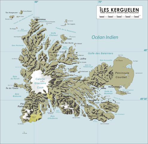
English: Map of the Kerguelen Islands, French Southern and Antarctic Territories
Deutsch: Karte des Kerguelen-Archipel |
||
| Dagsetning | 8. apríl 2006 (original upload date) | ||
| Uppruni | eigin skrá | ||
| Höfundarréttarhafi | Varp | ||
| Réttindi (Endurnotkun á þessari skrá) |
|
Breytingaskrá skjals
Smelltu á dagsetningu eða tímasetningu til að sjá hvernig hún leit þá út.
| Dagsetning/Tími | Smámynd | Víddir | Notandi | Athugasemd | |
|---|---|---|---|---|---|
| núverandi | 16. október 2008 kl. 13:04 | | 1.964 × 1.906 (337 KB) | Ralf Roletschek | {{Information |Description= |Source= |Date= |Author= |Permission= |other_versions= }} |
| 13. apríl 2006 kl. 07:40 |  | 1.964 × 1.906 (904 KB) | Varp~commonswiki | ||
| 12. apríl 2006 kl. 07:41 |  | 1.964 × 1.906 (866 KB) | Varp~commonswiki | ||
| 9. apríl 2006 kl. 10:14 |  | 1.964 × 1.906 (866 KB) | Varp~commonswiki | ||
| 8. apríl 2006 kl. 14:52 |  | 1.964 × 1.906 (853 KB) | Varp~commonswiki | *Map of the Kerguelen Islands, French Southern and Antarctic Territories *drawn by varp |
Skráartenglar
Eftirfarandi síða notar þessa skrá:
Altæk notkun skráar
Eftirfarandi wikar nota einnig þessa skrá:
- Notkun á als.wikipedia.org
- Notkun á ar.wikipedia.org
- Notkun á da.wikipedia.org
- Notkun á de.wikipedia.org
- Notkun á de.wikivoyage.org
- Notkun á de.wiktionary.org
- Notkun á el.wikipedia.org
- Notkun á en.wikipedia.org
- Notkun á es.wikipedia.org
- Notkun á et.wikipedia.org
- Notkun á frr.wikipedia.org
- Notkun á fr.wikipedia.org
- Notkun á gag.wikipedia.org
- Notkun á gl.wikipedia.org
- Notkun á hr.wikipedia.org
- Notkun á hu.wikipedia.org
- Notkun á id.wikipedia.org
- Notkun á ie.wikipedia.org
- Notkun á ka.wikipedia.org
- Notkun á lt.wikipedia.org
- Notkun á nds.wikipedia.org
- Notkun á nn.wikipedia.org
- Notkun á no.wikipedia.org
- Notkun á pl.wikipedia.org
- Notkun á pnb.wikipedia.org
- Notkun á ro.wikipedia.org
- Notkun á sk.wikipedia.org
- Notkun á sr.wikipedia.org
- Notkun á sv.wikipedia.org
- Notkun á ug.wikipedia.org
- Notkun á uk.wikipedia.org
- Notkun á ur.wikipedia.org
- Notkun á vi.wikipedia.org
- Notkun á war.wikipedia.org
- Notkun á zh.wikipedia.org