
Mynd:Indonesia 2002 CIA map.jpg
Stærð þessarar forskoðunar: 800 × 536 mynddílar Aðrar upplausnir: 320 × 214 mynddílar | 640 × 429 mynddílar | 1.024 × 686 mynddílar | 1.280 × 858 mynddílar | 2.000 × 1.340 mynddílar.
Upphafleg skrá (2.000 × 1.340 mynddílar, skráarstærð: 1,43 MB, MIME-gerð: image/jpeg)
Lýsing
| Lýsing |
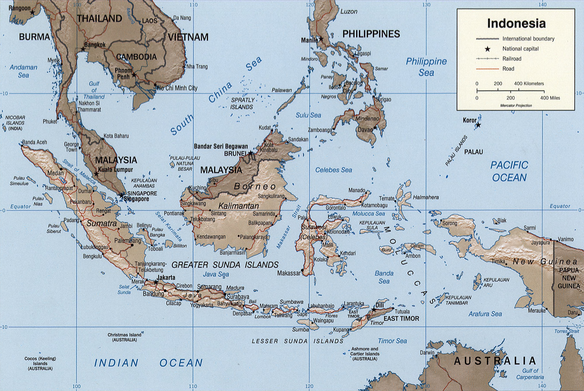
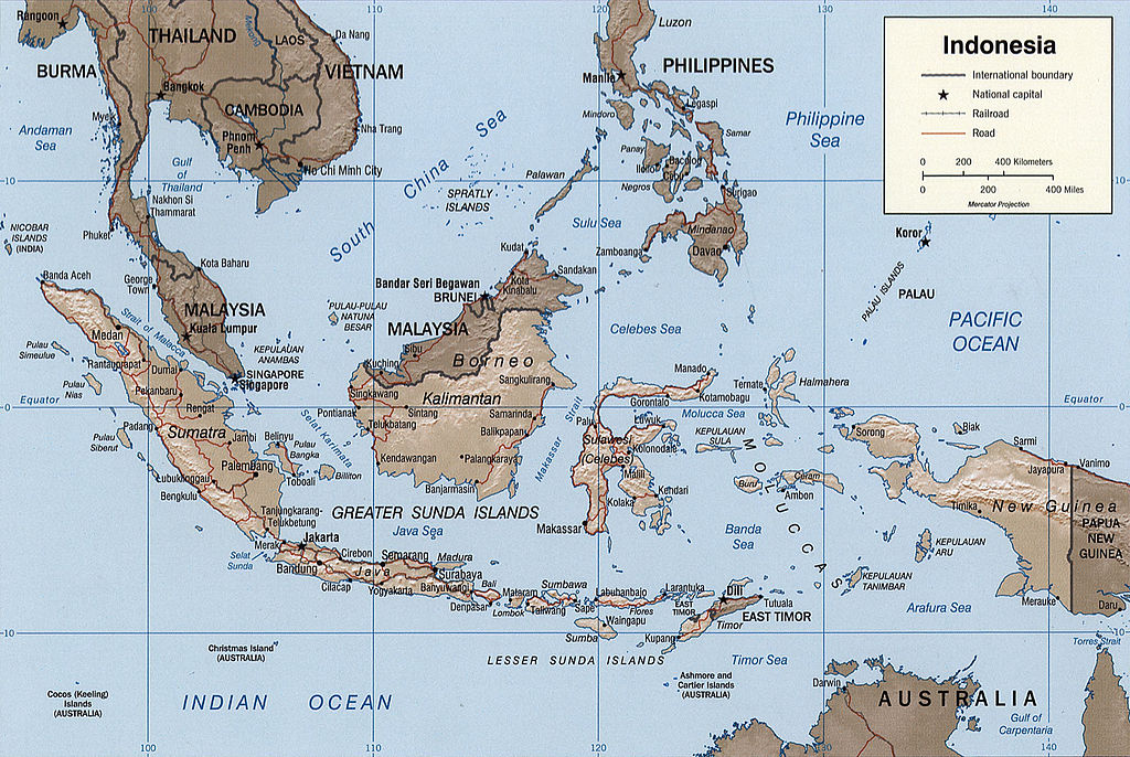
English: Map of Indonesia.
Français : Carte d'Indonésie. |
|||||||||||||||||||||||||
| Dagsetning | ||||||||||||||||||||||||||
| Uppruni |
|
|||||||||||||||||||||||||
| Höfundarréttarhafi | Central Intelligence Agency, United States of America | |||||||||||||||||||||||||
| Aðrar útgáfur |
|
|||||||||||||||||||||||||


Leyfisupplýsingar:
| This image is a work of a Central Intelligence Agency employee, taken or made as part of that person's official duties. As a Work of the United States Government, this image or media is in the public domain in the United States.
|

|
Original description
Indonesia.
United States. Central Intelligence Agency.
CREATED/PUBLISHED
[Washington, D.C. : Central Intelligence Agency, 2002]
NOTES
Relief shown by shading.
"Base 802899AI (C00429) 11-02."
Also issued without shaded relief.
Scale [ca. 1:25,000,000] ; Mercator proj. (E 1040--E 1430/N 170--S 150).
SUBJECTS
MEDIUM
1 map : col. ; 16 x 23 cm.
CALL NUMBER
G8070 2002 .U6
REPOSITORY
Library of Congress Geography and Map Division Washington, D.C. 20540-4650 USA
DIGITAL ID
g8070 ct000982 http://hdl.loc.gov/loc.gmd/g8070.ct000982
Breytingaskrá skjals
Smelltu á dagsetningu eða tímasetningu til að sjá hvernig hún leit þá út.
| Dagsetning/Tími | Smámynd | Víddir | Notandi | Athugasemd | |
|---|---|---|---|---|---|
| núverandi | 26. október 2005 kl. 03:39 | | 2.000 × 1.340 (1,43 MB) | Brian0918 | Indonesia. United States. Central Intelligence Agency. CREATED/PUBLISHED [Washington, D.C. : Central Intelligence Agency, 2002] NOTES Relief shown by shading. "Base 802899AI (C00429) 11-02." Also issued without shaded relief. Scale [ca. 1:25,000,000 |
Skráartenglar
Eftirfarandi síða notar þessa skrá:
Altæk notkun skráar
Eftirfarandi wikar nota einnig þessa skrá:
- Notkun á ace.wikipedia.org
- Notkun á ar.wikipedia.org
- Notkun á azb.wikipedia.org
- Notkun á az.wikipedia.org
- Notkun á bcl.wikipedia.org
- Notkun á bg.wikipedia.org
- Notkun á bs.wikipedia.org
- Notkun á da.wikipedia.org
- Notkun á de.wikipedia.org
- Notkun á el.wikipedia.org
- Notkun á en.wikipedia.org
- Notkun á eo.wikipedia.org
- Notkun á es.wikipedia.org
- Notkun á eu.wikipedia.org
- Notkun á fi.wikipedia.org
- Notkun á frr.wikipedia.org
- Notkun á fr.wikipedia.org
- Notkun á fr.wiktionary.org
- Notkun á gl.wikipedia.org
- Notkun á he.wikipedia.org
- Notkun á hy.wikipedia.org
- Notkun á id.wikipedia.org
- Notkun á id.wikisource.org
- Notkun á ja.wikipedia.org
- Notkun á ka.wikipedia.org
- Notkun á kk.wikipedia.org
- Notkun á mg.wikipedia.org
- Notkun á ms.wikipedia.org
- Notkun á mt.wikipedia.org
- Notkun á nn.wikipedia.org
- Notkun á pl.wikipedia.org
- Notkun á pl.wiktionary.org
- Notkun á pt.wikipedia.org
Skoða frekari altæka notkun þessarar skráar.