
Mynd:Haitian national palace earthquake.jpg

Stærð þessarar forskoðunar: 800 × 533 mynddílar Aðrar upplausnir: 320 × 213 mynddílar | 640 × 427 mynddílar | 1.024 × 683 mynddílar | 1.280 × 853 mynddílar | 3.000 × 2.000 mynddílar.
Upphafleg skrá (3.000 × 2.000 mynddílar, skráarstærð: 1,82 MB, MIME-gerð: image/jpeg)
Lýsing
| Lýsing |
Català: El Palau Nacional d'Haití greument danyat després del terratrèmol del 12 de gener del 2010. Port-au-Prince, Haití. Nota: aquest edifici era de dos plantes; la segona planta es va esfondrar completament.
Deutsch: Der Haitianische Nationalpalast (Präsidentenpalast), in Port-au-Prince, Haiti. Beachte: es handelt sich um ein zweistöckiges Gebäude, das zweite Stockwerk ist vollständig eingestürzt.
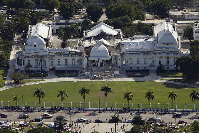
English: The Haitian National Palace (Presidential Palace), located in Port-au-Prince, Haiti, heavily damaged after the earthquake of January 12, 2010. Note: this was originally a two-story structure; the second story completely collapsed.
Español: El Palacio Nacional de Haití (Palacio Presidencial) severamente dañado tras el terremoto del 12 de enero de 2010. Port-au-Prince, Haití. Nota: este edificio era de dos plantas; el segundo piso se hundió completamente.
Suomi: Haitin presidentinpalatsi pahasti vaurioituneena 12. tammikuuta 2010 tapahtuneen maanjäristyksen jälkeen. Port-au-Prince, Haiti.
Français : Le Palais national sévèrement endommagé après le séisme du 12 janvier 2010 à Port-au-Prince, Haiti. A noter : il s'agit d'un bâtiment à deux étages, le deuxième étage s'est complèment effondré.
Italiano: Il Palazzo presidenziale di Haiti (Palazzo presidenziale) pesantemente danneggiato dopo il terremoto del 12 Gennaio 2010 a Port-au-Prince, Haiti. Nota: la struttura era originariamente a due piani; il secondo piano è collassato completamente. |
||||
| Dagsetning | |||||
| Uppruni | United Nations Development Programme, originally posted to Flickr as Haiti Earthquake | ||||
| Höfundarréttarhafi | Logan Abassi / UNDP Global | ||||
| Réttindi (Endurnotkun á þessari skrá) |
|
||||
| Aðrar útgáfur |
Derivative works of this file: Haitian national palace earthquake-edit.jpg
|


| Object location | | View this and other nearby images on: OpenStreetMap |
|---|
|
Leyfisupplýsingar:
This file is licensed under the Creative Commons Attribution 2.0 Generic license.
- Þér er frjálst:
- að deila – að afrita, deila og yfirfæra verkið
- að blanda – að breyta verkinu
- Undir eftirfarandi skilmálum:
- tilvísun höfundarréttar – Þú verður að tilgreina viðurkenningu á höfundarréttindum, gefa upp tengil á notkunarleyfið og gefa til kynna ef breytingar hafa verið gerðar. Þú getur gert þetta á einhvern ásættanlegan máta, en ekki á nokkurn þann hátt sem bendi til þess að leyfisveitandinn styðji þig eða notkun þína á verkinu.
Breytingaskrá skjals
Smelltu á dagsetningu eða tímasetningu til að sjá hvernig hún leit þá út.
| Dagsetning/Tími | Smámynd | Víddir | Notandi | Athugasemd | |
|---|---|---|---|---|---|
| núverandi | 14. janúar 2010 kl. 18:18 | | 3.000 × 2.000 (1,82 MB) | Flickr upload bot | Uploaded from http://flickr.com/photo/37913760@N03/4274663582 using Flickr upload bot |
Skráartenglar
Eftirfarandi síða notar þessa skrá:
Altæk notkun skráar
Eftirfarandi wikar nota einnig þessa skrá:
- Notkun á ar.wikipedia.org
- Notkun á arz.wikipedia.org
- Notkun á ast.wikipedia.org
- Notkun á bg.wikinews.org
- Notkun á ca.wikipedia.org
- Notkun á ckb.wikipedia.org
- Notkun á cs.wikipedia.org
- Notkun á da.wikipedia.org
- Jordskælvet i Haiti 2010
- Hédi Annabi
- Zilda Arns
- Skabelon:Navboks Jordskælvet i Haiti 2010
- Port-au-Prince (arrondissement)
- Christopher Hotel
- Léogâne
- Georges Anglade
- Carrefour (Haiti)
- Luiz Carlos da Costa
- Joseph Serge Miot
- Michel Gaillard
- Sam Dixon
- Jimmy O
- Hôtel Montana
- Gressier
- Delmas (Haiti)
- Præsidentpaladset (Haiti)
- Notkun á de.wikipedia.org
- Notkun á en.wikipedia.org
Skoða frekari altæka notkun þessarar skráar.