
Mynd:GulfofMaine.jpg
Það er engin hærri upplausn til.
GulfofMaine.jpg (523 × 544 mynddílar, skráarstærð: 285 KB, MIME-gerð: image/jpeg)
Origin
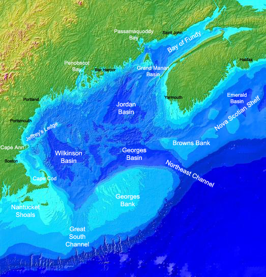
Found on the english Wikipedia Image :GulfofMaine.jpg. Digital bathymetry map of the Gulf of Maine. Credit: National Oceanographic and Atmospheric Administration and U.S. Geological Survey (USGS) Woods Hole, MA Labels by Syagria.)
Lýsing
Digital bathymetry map of the Gulf of Maine. Credit: National Oceanographic and Atmospheric Administration and U.S. Geological Survey (USGS) Woods Hole, MA. Labels by Syagria.
Leyfisupplýsingar:
This image is in the public domain because it contains materials that originally came from the U.S. National Oceanic and Atmospheric Administration, taken or made as part of an employee's official duties.
|
Breytingaskrá skjals
Smelltu á dagsetningu eða tímasetningu til að sjá hvernig hún leit þá út.
| Dagsetning/Tími | Smámynd | Víddir | Notandi | Athugasemd | |
|---|---|---|---|---|---|
| núverandi | 27. nóvember 2006 kl. 00:32 | | 523 × 544 (285 KB) | TCY | ==Origin== Found on the english Wikipedia [http://en.wikipedia.org/wiki/Image:GulfofMaine.jpg Image :GulfofMaine.jpg] == Summary == Digital bathymetry map of the Gulf of Maine. Credit: National Oceanographic and Atmospheric Administration and U.S. Geolog |
Skráartenglar
Eftirfarandi síða notar þessa skrá:
Altæk notkun skráar
Eftirfarandi wikar nota einnig þessa skrá:
- Notkun á az.wikipedia.org
- Notkun á be.wikipedia.org
- Notkun á bg.wikipedia.org
- Notkun á ca.wikipedia.org
- Notkun á ce.wikipedia.org
- Notkun á da.wikipedia.org
- Notkun á en.wikipedia.org
- Notkun á en.wikiversity.org
- Notkun á es.wikipedia.org
- Notkun á eu.wikipedia.org
- Notkun á fa.wikipedia.org
- Notkun á fi.wikipedia.org
- Notkun á fr.wikipedia.org
- Notkun á gl.wikipedia.org
- Notkun á hr.wikipedia.org
- Notkun á id.wikipedia.org
- Notkun á ka.wikipedia.org
- Notkun á ko.wikipedia.org
- Notkun á lt.wikipedia.org
- Notkun á ml.wikipedia.org
- Notkun á pt.wikipedia.org
- Notkun á ru.wikipedia.org
- Notkun á ta.wikipedia.org
- Notkun á zh.wikipedia.org