Mynd:First century Iudaea province.gif
Page contents not supported in other languages.
Úr Wikipediu, frjálsa alfræðiritinu

Upphafleg skrá(575 × 792 mynddílar, skráarstærð: 31 KB, MIME-gerð: image/gif)

Skrá þessi er af Wikimedia Commons, og deilt meðal annarra verkefna og nýtist því þar. Hér fyrir neðan er afrit af skráarsíðunni þar.

This map image could be re-created using vector graphics as an SVG file. This has several advantages; see Commons:Media for cleanup for more information. If an SVG form of this image is available, please upload it and afterwards replace this template with {{vector version available|new image name}}.


It is recommended to name the SVG file “First century Iudaea province.svg”—then the template Vector version available (or Vva) does not need the new image name parameter.

Lýsing

Lýsing
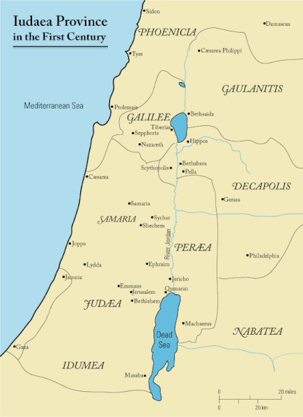
English: This is a map of first century Iudaea Province that I created using Illustrator CS2. I traced this image for the general geographic features. I then manually input data from maps found in a couple of sources.
  • Robert W. Funk and the Jesus Seminar. The Acts of Jesus. HarperSanFrancisco: 1998. p. xxiv.
  • Michael Grant. Jesus: An Historian's Review of the Gospels. Charles Scribner's Sons: 1977. p. 65-67.
  • John P. Meier. A Marginal Jew. Doubleday: 1991. p. 1:434.
Dagsetning 23. mars 2006 (original upload date)
Uppruni Transferred from en.wikipedia to Commons.
Höfundarréttarhafi Andrew c at enska Wikipedia
Réttindi
(Endurnotkun á þessari skrá)
Released under the GNU Free Documentation License or CC-BY.
Aðrar útgáfur العربيَّة

Leyfisupplýsingar:

Andrew c from en.wikipedia.org, the copyright holder of this work, hereby publishes it under the following license:
GNU head Gefið er leyfi til að afrita, dreifa og/eða breyta þessu skjali samkvæmt Frjálsa GNU Free Documentation License, útgáfu 1.2 eða nýrri, sem gefið er út af Frjálsu hugbúnaðarstofnuninni með engum breytingum þar á. Afrit af leyfinu er innifalið í kaflanum GNU Free Documentation License. Subject to disclaimers.
w:en:Creative Commons
tilvísun höfundarréttar
This file is licensed under the Creative Commons Attribution 3.0 Unported license.
Tilvísun höfundarréttar: Wikipedia User:Andrew c
Þér er frjálst:
  • að deila – að afrita, deila og yfirfæra verkið
  • að blanda – að breyta verkinu
Undir eftirfarandi skilmálum:
  • tilvísun höfundarréttar – Þú verður að tilgreina viðurkenningu á höfundarréttindum, gefa upp tengil á notkunarleyfið og gefa til kynna ef breytingar hafa verið gerðar. Þú getur gert þetta á einhvern ásættanlegan máta, en ekki á nokkurn þann hátt sem bendi til þess að leyfisveitandinn styðji þig eða notkun þína á verkinu.
Public domain I, the copyright holder of this work, release this work into the public domain. This applies worldwide.
In some countries this may not be legally possible; if so:
I grant anyone the right to use this work for any purpose, without any conditions, unless such conditions are required by law.

Original upload log

The original description page was here. All following user names refer to en.wikipedia.
  • 2006-03-24 18:48 Andrew c 575×792×8 (32374 bytes) This is a map of First Century Palestine that I created using Illustrator CS2. I traced [http://commons.wikimedia.org/wiki/Image:Map_of_administrative_regions_in_Israel.png this] image for the general geographic features. I then manually input data from m
  • 2006-03-23 19:48 Andrew c 587×790×8 (30752 bytes) This is a map of First Century Palestine that I created using Illustrator CS2. I traced [http://commons.wikimedia.org/wiki/Image:Map_of_administrative_regions_in_Israel.png this] image for the general geographic features. I then manually input data from m

Captions

Add a one-line explanation of what this file represents
Judaea province in the 1st Century CE

Items portrayed in this file

depicts enska

Judaea enska

23. mars 2006

MIME type enska

image/gif

checksum enska

e488e0183049d2138c916ccc7a24c107807f12b7

data size enska

32.019 Bæti

792 díll

575 díll

Breytingaskrá skjals

Smelltu á dagsetningu eða tímasetningu til að sjá hvernig hún leit þá út.

Dagsetning/TímiSmámyndVíddirNotandiAthugasemd
núverandi18. september 2011 kl. 11:47Smámynd útgáfunnar frá 18. september 2011, kl. 11:47575 × 792 (31 KB)OnceinawhileRemoved region-name "Philistia", as incorrect
13. september 2007 kl. 14:05Smámynd útgáfunnar frá 13. september 2007, kl. 14:05575 × 792 (32 KB)Liftarn{{SVG|map}} {{Information |Description=This is a map of first century en:Iudaea Province that I created using Illustrator CS2. I traced [http://commons.wikimedia.org/wiki/Image:Map_of_administrative_regions_in_Israel.png this] image for the general g
30. apríl 2006 kl. 00:29Smámynd útgáfunnar frá 30. apríl 2006, kl. 00:29575 × 792 (32 KB)Duende~commonswikihttp://en.wikipedia.org/wiki/Image:First_century_palestine.gif

Eftirfarandi síða notar þessa skrá:

Altæk notkun skráar

Eftirfarandi wikar nota einnig þessa skrá:

Skoða frekari altæka notkun þessarar skráar.