
Mynd:Austrian Empire (1815).svg

Stærð þessarar PNG forskoðunar á SVG skránni: 450 × 456 mynddílar. Aðrar upplausnir: 237 × 240 mynddílar | 474 × 480 mynddílar | 758 × 768 mynddílar | 1.011 × 1.024 mynddílar | 2.021 × 2.048 mynddílar.
Upphafleg skrá (SVG-skrá, að nafni til 450 × 456 mynddílar, skráarstærð: 691 KB)
Lýsing


.svg)
.svg)
.svg)
.svg)
.svg)


.svg)
.svg)
.svg)


.png)
.png)


.svg)


.svg)

.svg)


.svg)
.svg)
.svg)
.svg)


.svg)
.png)


.svg)


.svg)
.svg)


.svg)


.svg)


.svg)
.svg)
.svg)
.svg)
.svg)
.svg)
.svg)
.svg)
_cropped.svg)
.svg)
.svg)
.svg)
.svg)
.svg)
.svg)
.svg)
.svg)
.svg)
.svg)
.svg)
.svg)
.svg)
.svg)
.svg)
.svg)
.svg)
.svg)
.svg)
.svg)
.svg)
.svg)
.svg)
.svg)
.svg)
.svg)
.svg)
.svg)
.svg)
.svg)
.svg)
.svg)
.svg)
.svg)
.svg)
.svg)
.svg)
.svg)
.svg)
.svg)
.svg)
.svg)
.svg)
.svg)
.svg)
Breytingaskrá skjals
Smelltu á dagsetningu eða tímasetningu til að sjá hvernig hún leit þá út.
| Dagsetning/Tími | Smámynd | Víddir | Notandi | Athugasemd | |
|---|---|---|---|---|---|
| núverandi | 16. apríl 2019 kl. 09:58 | | 450 × 456 (691 KB) | TRAJAN 117 | +++ |
| 12. ágúst 2013 kl. 21:20 |  | 450 × 456 (654 KB) | TRAJAN 117 | Update | |
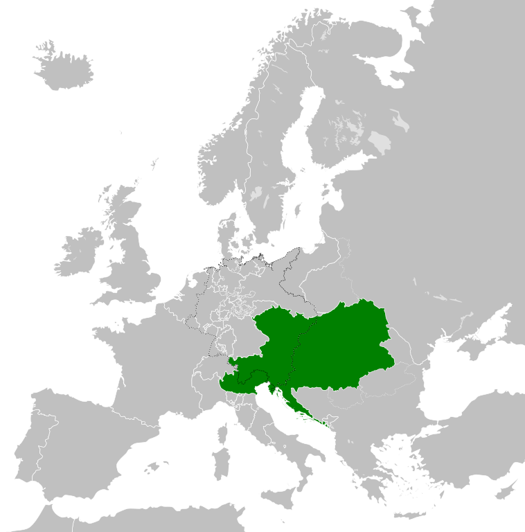
| 12. ágúst 2013 kl. 05:47 |  | 450 × 456 (1 MB) | TRAJAN 117 | {{Information |Description ={{en|1=The Austrian Empire in 1815.}} |Source ={{own}} {{AttribSVG|Blank map of Europe 1815.svg|Alphathon}} |Author =TRAJAN 117 {{created with Inkscape}} |Date =2013-08-12 |Pe... |
Skráartenglar
Eftirfarandi síða notar þessa skrá:
Altæk notkun skráar
Eftirfarandi wikar nota einnig þessa skrá:
- Notkun á af.wikipedia.org
- Notkun á ast.wikipedia.org
- Notkun á azb.wikipedia.org
- Notkun á ba.wikipedia.org
- Notkun á bg.wikipedia.org
- Notkun á br.wikipedia.org
- Notkun á ce.wikipedia.org
- Notkun á cs.wikipedia.org
- Notkun á cy.wikipedia.org
- Notkun á de.wikipedia.org
- Notkun á el.wikipedia.org
- Notkun á en.wikipedia.org
- Notkun á es.wikipedia.org
- Notkun á fi.wikipedia.org
- Notkun á frr.wikipedia.org
- Notkun á fr.wikipedia.org
- Notkun á ga.wikipedia.org
- Notkun á gd.wikipedia.org
- Notkun á gl.wikipedia.org
- Notkun á he.wikipedia.org
- Notkun á hi.wikipedia.org
- Notkun á hr.wikipedia.org
- Notkun á hy.wikipedia.org
- Notkun á id.wikipedia.org
- Notkun á id.wikibooks.org
- Notkun á incubator.wikimedia.org
- Notkun á it.wikipedia.org
- Notkun á jam.wikipedia.org
- Notkun á ja.wikipedia.org
- Notkun á ka.wikipedia.org
- Notkun á km.wikipedia.org
- Notkun á ko.wikipedia.org
- Notkun á ky.wikipedia.org
- Notkun á lmo.wikipedia.org
- Notkun á lt.wikipedia.org
- Notkun á lv.wikipedia.org
- Notkun á mk.wikipedia.org
- Notkun á mn.wikipedia.org
- Notkun á nap.wikipedia.org
- Notkun á nl.wikipedia.org
- Notkun á pa.wikipedia.org
Skoða frekari altæka notkun þessarar skráar.
.svg)
.svg)