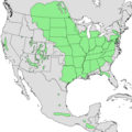
Mynd:Acer negundo range map.png

Stærð þessarar forskoðunar: 600 × 600 mynddílar Aðrar upplausnir: 240 × 240 mynddílar | 480 × 480 mynddílar | 1.012 × 1.012 mynddílar.
Upphafleg skrá (1.012 × 1.012 mynddílar, skráarstærð: 32 KB, MIME-gerð: image/png)
Breytingaskrá skjals
Smelltu á dagsetningu eða tímasetningu til að sjá hvernig hún leit þá út.
| Dagsetning/Tími | Smámynd | Víddir | Notandi | Athugasemd | |
|---|---|---|---|---|---|
| núverandi | 20. mars 2013 kl. 03:22 |  | 1.012 × 1.012 (32 KB) | Nonenmac | cropped a little differenly, that's all |
| 19. mars 2013 kl. 22:39 |  | 993 × 1.003 (31 KB) | Nonenmac | higher-resolution directly from the USGS map | |
| 30. maí 2011 kl. 17:34 |  | 732 × 759 (30 KB) | Nonenmac |
Skráartenglar
Eftirfarandi síða notar þessa skrá:
Altæk notkun skráar
Eftirfarandi wikar nota einnig þessa skrá:
- Notkun á arz.wikipedia.org
- Notkun á bg.wikipedia.org
- Notkun á ca.wikipedia.org
- Notkun á ceb.wikipedia.org
- Notkun á cs.wikipedia.org
- Notkun á cy.wikipedia.org
- Notkun á en.wikipedia.org
- Notkun á es.wikipedia.org
- Notkun á eu.wikipedia.org
- Notkun á fa.wikipedia.org
- Notkun á fr.wikipedia.org
- Notkun á ga.wikipedia.org
- Notkun á gl.wikipedia.org
- Notkun á hu.wikipedia.org
- Notkun á hy.wikipedia.org
- Notkun á it.wikipedia.org
- Notkun á ja.wikipedia.org
- Notkun á lt.wikipedia.org
- Notkun á no.wikipedia.org
- Notkun á ro.wikipedia.org
- Notkun á sr.wikipedia.org
- Notkun á sv.wikipedia.org
- Notkun á tr.wikipedia.org
- Notkun á tt.wikipedia.org
- Notkun á vi.wikipedia.org
- Notkun á www.wikidata.org
- Notkun á zh.wikipedia.org


