
Mynd:United Kingdom foreign born population by country of birth.png

Stærð þessarar forskoðunar: 800 × 353 mynddílar Aðrar upplausnir: 320 × 141 mynddílar | 940 × 415 mynddílar.
Upphafleg skrá (940 × 415 mynddílar, skráarstærð: 112 KB, MIME-gerð: image/png)

|
This demographic map image could be re-created using vector graphics as an SVG file. This has several advantages; see Commons:Media for cleanup for more information. If an SVG form of this image is available, please upload it and afterwards replace this template with
{{vector version available|new image name}}.
It is recommended to name the SVG file “United Kingdom foreign born population by country of birth.svg”—then the template Vector version available (or Vva) does not need the new image name parameter. |
Lýsing
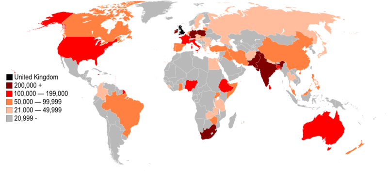
| Lýsing | A map of 60 world countries coloured by the estimated number of people born in that country living in the United Kingdom during April 2007 and March 2008. |
| Dagsetning | |
| Uppruni | Self-made from Population by Country of Birth and Nationality, 2008 |
| Höfundarréttarhafi | Jolly Janner |
| Aðrar útgáfur | Vector |
Leyfisupplýsingar:
| I, the copyright holder of this work, release this work into the public domain. This applies worldwide. In some countries this may not be legally possible; if so: I grant anyone the right to use this work for any purpose, without any conditions, unless such conditions are required by law. |
Breytingaskrá skjals
Smelltu á dagsetningu eða tímasetningu til að sjá hvernig hún leit þá út.
| Dagsetning/Tími | Smámynd | Víddir | Notandi | Athugasemd | |
|---|---|---|---|---|---|
| núverandi | 24. ágúst 2009 kl. 13:17 | | 940 × 415 (112 KB) | Jolly Janner | Changed the set of data from "[less than] 19,999" to "[less than] 20,999" per source. |
| 29. nóvember 2008 kl. 16:47 |  | 940 × 415 (112 KB) | Jolly Janner | {{Information |Description=A map of 60 world countries coloured by the number of people born in that country living in the United Kingdom during April 2007 and March 2008. |Source=Self-made |Date=29 November 2008 |Author=Jolly Janner |other_versions=[[:I |
Skráartenglar
Eftirfarandi síða notar þessa skrá:
Altæk notkun skráar
Eftirfarandi wikar nota einnig þessa skrá:
- Notkun á af.wikipedia.org
- Notkun á am.wikipedia.org
- Notkun á ar.wikipedia.org
- Notkun á cs.wikipedia.org
- Notkun á de.wikipedia.org
- Notkun á en.wikipedia.org
- Notkun á es.wikipedia.org
- Notkun á gu.wikipedia.org
- Notkun á hi.wikipedia.org
- Notkun á hu.wikipedia.org
- Notkun á id.wikipedia.org
- Notkun á it.wikipedia.org
- Notkun á kn.wikipedia.org
- Notkun á lt.wikipedia.org
- Notkun á ms.wikipedia.org
- Notkun á pt.wikipedia.org
- Notkun á rm.wikipedia.org
- Notkun á roa-tara.wikipedia.org
- Notkun á ro.wikipedia.org
- Notkun á sk.wikipedia.org
- Notkun á te.wikipedia.org
- Notkun á tl.wikipedia.org
- Notkun á uk.wikipedia.org