
Mynd:Map Gaels Brythons Picts.png

Stærð þessarar forskoðunar: 465 × 600 mynddílar Aðrar upplausnir: 186 × 240 mynddílar | 372 × 480 mynddílar | 643 × 829 mynddílar.
Upphafleg skrá (643 × 829 mynddílar, skráarstærð: 66 KB, MIME-gerð: image/png)

|
This linguistic map image could be re-created using vector graphics as an SVG file. This has several advantages; see Commons:Media for cleanup for more information. If an SVG form of this image is available, please upload it and afterwards replace this template with
{{vector version available|new image name}}.
It is recommended to name the SVG file “Map Gaels Brythons Picts.svg”—then the template Vector version available (or Vva) does not need the new image name parameter. |
Lýsing
| Lýsing |
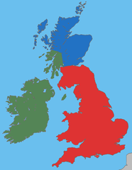
English: A map showing the approximate areas where the Gaelic (green), Brythonic (red) and Pictish (blue) languages were spoken during the 5th century CE; the period between the Roman withdrawal and the founding of Anglo-Saxon kingdoms. |
| Dagsetning | |
| Uppruni | Own work, based on File:Uk map home nations.png |
| Höfundarréttarhafi | User:Asarlaí |
Leyfisupplýsingar:
I, the copyright holder of this work, hereby publish it under the following licenses:

|
Gefið er leyfi til að afrita, dreifa og/eða breyta þessu skjali samkvæmt Frjálsa GNU Free Documentation License, útgáfu 1.2 eða nýrri, sem gefið er út af Frjálsu hugbúnaðarstofnuninni með engum breytingum þar á. Afrit af leyfinu er innifalið í kaflanum GNU Free Documentation License. |
This file is licensed under the Creative Commons Attribution-Share Alike 4.0 International, 3.0 Unported, 2.5 Generic, 2.0 Generic and 1.0 Generic license.
- Þér er frjálst:
- að deila – að afrita, deila og yfirfæra verkið
- að blanda – að breyta verkinu
- Undir eftirfarandi skilmálum:
- tilvísun höfundarréttar – Þú verður að tilgreina viðurkenningu á höfundarréttindum, gefa upp tengil á notkunarleyfið og gefa til kynna ef breytingar hafa verið gerðar. Þú getur gert þetta á einhvern ásættanlegan máta, en ekki á nokkurn þann hátt sem bendi til þess að leyfisveitandinn styðji þig eða notkun þína á verkinu.
- Deila eins – Ef þú breytir, yfirfærir eða byggir á þessu efni, þá mátt þú eingöngu dreifa því verki með sama eða svipuðu leyfi og upprunalega verkið er með.
Þú mátt velja notkunarleyfi að eigin vali.
Breytingaskrá skjals
Smelltu á dagsetningu eða tímasetningu til að sjá hvernig hún leit þá út.
| Dagsetning/Tími | Smámynd | Víddir | Notandi | Athugasemd | |
|---|---|---|---|---|---|
| núverandi | 27. mars 2009 kl. 04:37 | | 643 × 829 (66 KB) | Asarlaí | {{Information |Description={{en|1=A map showing the approximate areas where the Gaelic (green), Brythonic (red) and Pictish (blue) languages were spoken around 450-500 CE.}} |Source=Own work, based on [http://commons.wikimedia.org/wiki/File:Uk_map_home_na |
Skráartenglar
Eftirfarandi síða notar þessa skrá:
Altæk notkun skráar
Eftirfarandi wikar nota einnig þessa skrá:
- Notkun á af.wikipedia.org
- Notkun á an.wikipedia.org
- Notkun á azb.wikipedia.org
- Notkun á be-tarask.wikipedia.org
- Notkun á be.wikipedia.org
- Notkun á br.wikipedia.org
- Notkun á ca.wikipedia.org
- Notkun á cy.wikipedia.org
- Notkun á da.wikipedia.org
- Notkun á el.wikipedia.org
- Notkun á en.wikipedia.org
- Notkun á es.wikipedia.org
- Notkun á et.wikipedia.org
- Notkun á eu.wikipedia.org
- Notkun á fi.wikibooks.org
- Notkun á fr.wikipedia.org
- Notkun á fy.wikipedia.org
- Notkun á ga.wikipedia.org
- Notkun á gl.wikipedia.org
- Notkun á ja.wikipedia.org
- Notkun á nds-nl.wikipedia.org
- Notkun á no.wikipedia.org
- Notkun á pl.wikipedia.org
- Notkun á pt.wikipedia.org
Skoða frekari altæka notkun þessarar skráar.