Mynd:Manchester Dock No 9.jpg

Page contents not supported in other languages.
Úr Wikipediu, frjálsa alfræðiritinu

Manchester_Dock_No_9.jpg(788 × 425 mynddílar, skráarstærð: 73 KB, MIME-gerð: image/jpeg)

Skrá þessi er af Wikimedia Commons, og deilt meðal annarra verkefna og nýtist því þar. Hér fyrir neðan er afrit af skráarsíðunni þar.

Lýsing
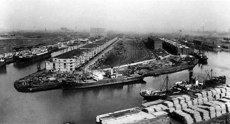
English: Dock No. 9 (top left) of the Salford Docks, Salford, Greater Manchester, England. Dock No. 8 is at the right and the Ship Canal in the foreground
Dagsetning circa 1900
date QS:P,+1900-00-00T00:00:00Z/9,P1480,Q5727902
Uppruni www.oldukphotos.com (with permission)
Höfundarréttarhafi ÓþekkturUnknown author
Réttindi
(Endurnotkun á þessari skrá)
Public domain logo
This UK artistic or literary work, of which the author is unknown and cannot be ascertained by reasonable enquiry, is in the public domain because it is one of the following:
  • A photograph, which has never previously been made available to the public (e.g. by publication or display at an exhibition) and which was taken more than 70 years ago (before 1 January 1954); or
  • A photograph, which was made available to the public (e.g. by publication or display at an exhibition) more than 70 years ago (before 1 January 1954); or
  • An artistic work other than a photograph (e.g. a painting), or a literary work, which was made available to the public (e.g. by publication or display at an exhibition) more than 70 years ago (before 1 January 1954).

Warning sign This tag can be used only when the author cannot be ascertained by reasonable enquiry. If you wish to rely on it, please specify in the image description the research you have carried out to find who the author was. The above is all subject to any overriding publication right which may exist. In practice, publication right will often override the first of the bullet points listed.

Unpublished anonymous paintings remain in copyright until at least 1 January 2040. This tag does not apply to engravings or musical works. More information
Camera location53° 28′ 11,28″ N, 2° 17′ 57,48″ W Kartographer map based on OpenStreetMap.View this and other nearby images on: OpenStreetMapinfo

Captions

Add a one-line explanation of what this file represents

Items portrayed in this file

depicts enska

53°28'11.3"N, 2°17'57.5"W

Breytingaskrá skjals

Smelltu á dagsetningu eða tímasetningu til að sjá hvernig hún leit þá út.

Dagsetning/TímiSmámyndVíddirNotandiAthugasemd
núverandi22. janúar 2009 kl. 13:36Smámynd útgáfunnar frá 22. janúar 2009, kl. 13:36788 × 425 (73 KB)Jza84{{Information |Description={{en|1=Dock No. 9 of the Salford Docks, Salford, Greater Manchester, England.}} |Source=[http://www.oldukphotos.com/graphics/England%20Photos/Lancashire,%20Manchester,%20Ship%20Canal%20II.jpg www.oldukphotos.com] (with [http://w

Eftirfarandi síða notar þessa skrá:

Altæk notkun skráar

Eftirfarandi wikar nota einnig þessa skrá:

Lýsigögn