
Mynd:Location greek ancient.png
Það er engin hærri upplausn til.
Location_greek_ancient.png (248 × 113 mynddílar, skráarstærð: 4 KB, MIME-gerð: image/png)
Lýsing
| Lýsing |
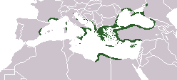
English: Locator map depicting the ancient Greek world, c. 550 BC |
|||
| Dagsetning | ||||
| Uppruni | Self-created, after http://www.wwnorton.com/nrl/english/nawol/maps/MAP7GRCO.JPG | |||
| Höfundarréttarhafi | User:ChrisO | |||
| Réttindi (Endurnotkun á þessari skrá) |
|
|||
| Aðrar útgáfur |
|


Breytingaskrá skjals
Smelltu á dagsetningu eða tímasetningu til að sjá hvernig hún leit þá út.
| Dagsetning/Tími | Smámynd | Víddir | Notandi | Athugasemd | |
|---|---|---|---|---|---|
| núverandi | 27. september 2021 kl. 16:20 | | 248 × 113 (4 KB) | Deji Olajide1999 | Added the missing regions of Orestis, Elimiotis, Eordaia and Tymphaea + cleared up the Greek colonies in Thrace. |
| 23. janúar 2018 kl. 09:22 |  | 248 × 113 (4 KB) | Maphobbyist | Added Colchis. | |
| 26. júní 2014 kl. 16:15 |  | 248 × 113 (6 KB) | SilentResident | Added missing kingdom of Epirus | |
| 29. desember 2012 kl. 10:55 |  | 248 × 113 (5 KB) | Gepgepgep | Aggiunta l'area di colonizzazione greca dell'Adriatico, che mancava completamente | |
| 5. september 2011 kl. 17:22 |  | 248 × 113 (5 KB) | Spesh531 | Showing borders that are recognized. Still showing unrecognized countries for a reference of where Ancient Greek was. It was also about the shape of the lands, as Greek Islands where either not shown correctly or not there at all | |
| 5. september 2011 kl. 13:00 |  | 248 × 113 (4 KB) | Maphobbyist | Pfrevious user Saguamundi is right. International borders, and NOT disputed borders must be shown. Nor is this about the present but about historical Greek settlements. There is no place for current politics for a historical map. | |
| 4. september 2011 kl. 22:28 |  | 248 × 113 (5 KB) | Spesh531 | Reverted to version as of 01:56, 11 May 2011 The border were fine, your showing territories where some are unrecognizable | |
| 4. september 2011 kl. 22:21 |  | 248 × 113 (5 KB) | Spesh531 | Reverted to version as of 01:56, 11 May 2011 The border were fine, your showing territories where some are unrecognizable | |
| 4. september 2011 kl. 21:26 |  | 248 × 113 (4 KB) | Saguamundi | Same map but with internationally recognized borders. | |
| 11. maí 2011 kl. 01:56 |  | 248 × 113 (5 KB) | Spesh531 | update more to source, the current Greece was not under territory. |
Skráartenglar
Það eru engar síður sem nota þessa skrá.
Altæk notkun skráar
Eftirfarandi wikar nota einnig þessa skrá:
- Notkun á en.wikipedia.org
- Notkun á pl.wikibooks.org