
Mynd:EnglandHerefordshire.svg

Stærð þessarar PNG forskoðunar á SVG skránni: 200 × 247 mynddílar. Aðrar upplausnir: 194 × 240 mynddílar | 389 × 480 mynddílar | 622 × 768 mynddílar | 829 × 1.024 mynddílar | 1.658 × 2.048 mynddílar.
Upphafleg skrá (SVG-skrá, að nafni til 200 × 247 mynddílar, skráarstærð: 231 KB)
Lýsing
| Lýsing |
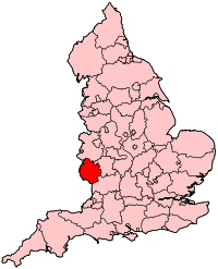
English: Map of the county of Herefordshire. |
| Uppruni | eigin skrá |
| Höfundarréttarhafi | Wereon |
Leyfisupplýsingar:
| I, the copyright holder of this work, release this work into the public domain. This applies worldwide. In some countries this may not be legally possible; if so: I grant anyone the right to use this work for any purpose, without any conditions, unless such conditions are required by law. |
Breytingaskrá skjals
Smelltu á dagsetningu eða tímasetningu til að sjá hvernig hún leit þá út.
| Dagsetning/Tími | Smámynd | Víddir | Notandi | Athugasemd | |
|---|---|---|---|---|---|
| núverandi | 22. apríl 2007 kl. 20:25 | | 200 × 247 (231 KB) | Wereon | Map of the county of Herefordshire. Category:Maps of counties of England |
Skráartenglar
Eftirfarandi síða notar þessa skrá:
Altæk notkun skráar
Eftirfarandi wikar nota einnig þessa skrá:
- Notkun á ast.wikipedia.org
- Notkun á be.wikipedia.org
- Notkun á br.wikipedia.org
- Notkun á cy.wikipedia.org
- Notkun á en.wikipedia.org
- Notkun á et.wikipedia.org
- Notkun á eu.wikipedia.org
- Notkun á fr.wikipedia.org
- Notkun á fy.wikipedia.org
- Notkun á hu.wiktionary.org
- Notkun á id.wikipedia.org
- Notkun á io.wikipedia.org
- Notkun á kw.wikipedia.org
- Notkun á lb.wikipedia.org
- Notkun á mr.wikipedia.org
- Notkun á mwl.wikipedia.org
- Notkun á nn.wikipedia.org
- Notkun á pl.wikipedia.org
- Notkun á ru.wikipedia.org
- Notkun á sk.wikipedia.org
- Notkun á sv.wikipedia.org
- Notkun á uk.wikipedia.org
- Notkun á vo.wikipedia.org
- Notkun á zh.wikipedia.org