
Mynd:Claudius Ptolemy- The World.jpg

Stærð þessarar forskoðunar: 800 × 576 mynddílar Aðrar upplausnir: 320 × 230 mynddílar | 640 × 461 mynddílar | 1.024 × 737 mynddílar | 1.280 × 922 mynddílar | 2.560 × 1.843 mynddílar | 8.073 × 5.813 mynddílar.
Upphafleg skrá (8.073 × 5.813 mynddílar, skráarstærð: 18,03 MB, MIME-gerð: image/jpeg)
| Listamaður |
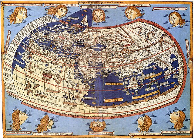
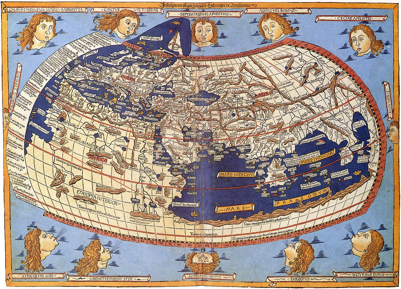
Lord Nicolas the German (Donnus Nicholas Germanus), cartographer Johann the Blockcutter of Armsheim (Johannes Schnitzer or Johannes de Armssheim), engraver |
||||
| Höfundarréttarhafi | |||||
| Lýsing |
English: The world map from Leinhart Holle's 1482 edition of Nicolaus Germanus's emendations to Jacobus Angelus's 1406 Latin translation of Maximus Planudes's late-13th century rediscovered Greek manuscripts of Ptolemy's 2nd-century Geography. |
||||
| Dagsetning | 1482 | ||||
| Source/Photographer | Decorative Maps by Roderick Barron - ISBN 1851702989 | ||||
| Réttindi (Endurnotkun á þessari skrá) |
|
||||
| Aðrar útgáfur |
|
||||


Breytingaskrá skjals
Smelltu á dagsetningu eða tímasetningu til að sjá hvernig hún leit þá út.
| Dagsetning/Tími | Smámynd | Víddir | Notandi | Athugasemd | |
|---|---|---|---|---|---|
| núverandi | 31. október 2023 kl. 08:26 | | 8.073 × 5.813 (18,03 MB) | OnlySlightlyDamp | Reverted to version as of 03:58, 3 July 2007 (UTC) |
| 22. október 2023 kl. 08:08 |  | 8.226 × 5.919 (19,53 MB) | Shekishekiey | Reverted to version as of 03:54, 3 July 2007 (UTC) | |
| 3. júlí 2007 kl. 03:58 |  | 8.073 × 5.813 (18,03 MB) | SCEhardt | cropped & rotated | |
| 3. júlí 2007 kl. 03:54 |  | 8.226 × 5.919 (19,53 MB) | SCEhardt | {{Information |Description=Claudius Ptolemy: The World |Source=Scanned by Scott Ehardt from Decorative Maps by Roderick Barron - ISBN 1851702989 |Date=1482 |Author=Johannes Schnitzer, engraver<br>Claudius Ptolemy, cartographer |Permissio |
Skráartenglar
Eftirfarandi síða notar þessa skrá:
Altæk notkun skráar
Eftirfarandi wikar nota einnig þessa skrá:
- Notkun á af.wikipedia.org
- Notkun á ar.wikipedia.org
- Notkun á az.wikipedia.org
- Notkun á be.wikipedia.org
- Notkun á bg.wikipedia.org
- Notkun á bh.wikipedia.org
- Notkun á bn.wikipedia.org
- Notkun á br.wikipedia.org
- Notkun á ca.wikipedia.org
- Notkun á de.wikipedia.org
- Notkun á el.wikipedia.org
- Notkun á en.wikipedia.org
- Notkun á eo.wikipedia.org
- Notkun á es.wikipedia.org
- Notkun á eu.wikipedia.org
- Notkun á fa.wikipedia.org
- Notkun á fr.wikipedia.org
- Notkun á fr.wikiversity.org
- Notkun á fy.wikipedia.org
- Notkun á ga.wikipedia.org
- Notkun á hi.wikipedia.org
- Notkun á hu.wikipedia.org
- Notkun á hy.wikipedia.org
- Notkun á id.wikipedia.org
Skoða frekari altæka notkun þessarar skráar.