
Mynd:Cartedujapon.png
Það er engin hærri upplausn til.
Cartedujapon.png (480 × 513 mynddílar, skráarstærð: 240 KB, MIME-gerð: image/png)

|
This locator map image could be re-created using vector graphics as an SVG file. This has several advantages; see Commons:Media for cleanup for more information. If an SVG form of this image is available, please upload it and afterwards replace this template with
{{vector version available|new image name}}.
It is recommended to name the SVG file “Cartedujapon.svg”—then the template Vector version available (or Vva) does not need the new image name parameter. |
Lýsing
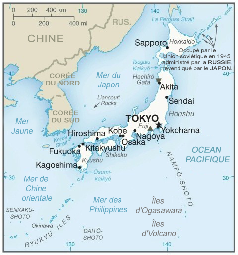
| Lýsing | Map in French of Japan |
| Dagsetning | translation : March 2004 |
| Uppruni | CIA World Factbook (via the French speaking Wikipedia) |
| Höfundarréttarhafi | of the translation : fr:Rinaldum |
| Réttindi (Endurnotkun á þessari skrá) |
PD |
Français : * Sujet : Carte en français du Japon ;
- Source : CIA World Factbook (via la Wikipédia francophone) ;
- Auteur de la traduction : fr:Rinaldum ;
- Date : Mars 2004.
File history on the French speaking Wikipedia :
(suppr) (actu) 2 mars 2004 à 16:28 . . Rinaldum (Discuter | Contributions) . . 351×377 (79 421 octets) (carte du japon (en français))
Leyfisupplýsingar:
This image is in the public domain because it contains materials that originally came from the United States Central Intelligence Agency's World Factbook.
|
 |
Breytingaskrá skjals
Smelltu á dagsetningu eða tímasetningu til að sjá hvernig hún leit þá út.
| Dagsetning/Tími | Smámynd | Víddir | Notandi | Athugasemd | |
|---|---|---|---|---|---|
| núverandi | 7. febrúar 2020 kl. 06:17 | | 480 × 513 (240 KB) | Artanisen | Carte plus récente du Japon. Fabriqué par la CIA. Source: https://www.cia.gov/library/publications/the-world-factbook/geos/ja.html |
| 22. júlí 2014 kl. 06:26 |  | 351 × 377 (93 KB) | Simba Hekima | a écrit le nom de la mer en détail | |
| 29. september 2006 kl. 14:45 |  | 351 × 377 (78 KB) | Loveless | This image was copied from wikipedia:fr. The original description was: '''Titre:''' carte du japon (en français)<br /> '''Licence:''' {{DomainePublic}}<br /> '''Source:''' provenant du fr:CIA World Factbook fr:Catégorie:Cartes du Japon {| b |
Skráartenglar
Það eru engar síður sem nota þessa skrá.
Altæk notkun skráar
Eftirfarandi wikar nota einnig þessa skrá:
- Notkun á fr.wikipedia.org
- Japon
- Portail:Japon/temporaire
- Portail:Japon/Article de la semaine archive
- Utilisateur:Eden2004/Portail Japon base
- Utilisateur:Eden2004/Portail Japon
- Utilisateur:Eden2004/Portail Japon/Portail Japon Nature
- Utilisateur:Eden2004/Portail Japon/Portail Japon Histoire
- Utilisateur:Eden2004/Portail Japon/Portail Japon Arts
- Portail:Japon
- Utilisateur:Settychea/Livres/Le japon
- Utilisateur:Kohfuku/Brouillon
- Portail:Japon/Géographie
- Notkun á gcr.wikipedia.org
- Notkun á ht.wikipedia.org
- Notkun á nrm.wikipedia.org
- Notkun á so.wikipedia.org