
Mynd:Bosnia and Hercegovina map.png

Upphafleg skrá (2.302 × 2.901 mynddílar, skráarstærð: 1,5 MB, MIME-gerð: image/png)
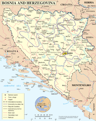
UN Bosnia and Hercegovina map
| Lýsing | Map of Bosnia and Hercegovina | |||
| Dagsetning | ||||
| Uppruni | The Cartographic Section of the United Nations (CSUN) | |||
| Höfundarréttarhafi | Cartographer of the United Nations | |||
| Réttindi (Endurnotkun á þessari skrá) |
|

Breytingaskrá skjals
Smelltu á dagsetningu eða tímasetningu til að sjá hvernig hún leit þá út.
| Dagsetning/Tími | Smámynd | Víddir | Notandi | Athugasemd | |
|---|---|---|---|---|---|
| núverandi | 11. maí 2010 kl. 16:48 | | 2.302 × 2.901 (1,5 MB) | Ras67 | cropped |
| 23. október 2007 kl. 01:26 |  | 2.348 × 2.948 (2,05 MB) | Jeroen | Higher reolution | |
| 9. mars 2007 kl. 23:03 |  | 1.880 × 2.349 (1,28 MB) | Minestrone | UN Bosnia and Hercegovina map {{Information |Description=Map of Bosnia and Hercegovina |Source=The Cartographic Section of the United Nations (CSUN) |Date=2007-03-10 |Author=Cartographer of the United Nations |Permission={{Template:UN map}} and the |
Skráartenglar
Það eru engar síður sem nota þessa skrá.
Altæk notkun skráar
Eftirfarandi wikar nota einnig þessa skrá:
- Notkun á ace.wikipedia.org
- Notkun á als.wikipedia.org
- Notkun á an.wikipedia.org
- Notkun á bcl.wikipedia.org
- Notkun á ckb.wikipedia.org
- Notkun á cu.wikipedia.org
- Notkun á de.wikipedia.org
- Notkun á en.wikipedia.org
- Notkun á fa.wikipedia.org
- Notkun á frr.wikipedia.org
- Notkun á gd.wikipedia.org
- Notkun á hy.wikipedia.org
- Notkun á id.wikipedia.org
- Notkun á incubator.wikimedia.org
- Notkun á ja.wikipedia.org
- Notkun á jv.wikipedia.org
- Notkun á kg.wikipedia.org
- Notkun á ki.wikipedia.org
- Notkun á ln.wikipedia.org
- Notkun á my.wikipedia.org
- Notkun á mzn.wikipedia.org
- Notkun á nl.wikipedia.org
- Notkun á nov.wikipedia.org
- Notkun á pl.wiktionary.org
- Notkun á ru.wikipedia.org
- Notkun á sl.wikipedia.org
- Notkun á sq.wikinews.org
- Notkun á uk.wikipedia.org
- Notkun á uk.wiktionary.org
Skoða frekari altæka notkun þessarar skráar.